Cycling the Babusar Pass
The bicycle does not get any respect in Pakistan. It is considered a mode of transportation only for the poor, and it is an absolute disgrace to be poor in a poor country. Cycling is very dangerous here as there is no concept of separate lanes for cyclists and traffic is horrendous. I however still commute between home and work on a bicycle. I can list a number of reasons for doing so. Cycling is environment friendly and it is a good exercise, but the main reason is that I enjoy cycling. The pleasure of riding a bike outweighs all hazards I have to face on the road. Driving a car in Lahore’s traffic is a hassle that I find too stressful for my nerves. Fortunately I live in an area such that it is possible for me to choose a route that avoids heavy traffic when riding to work. And since I ride the same route almost daily I know all the risky turns and corners on the route and have learnt how to avoid or negotiate them. Cycling is not physically tiring at all if it is done regularly. So I reach my office intact, fresh and having done very useful exercise in about the same time that I would take if I drive instead and reach for work half dead because of the stress I would face by driving in a very bizarre traffic.
Another oddity (oddity in our country) is that I like trekking and spend a few days every summer trekking in the northern areas. A couple of years ago I decided to try mountain biking and bought the best mountain bike that was available in Lahore. But I could not find any sort of bicycle panniers from anywhere. A friend of mine has a tailoring shop, using my ingenuity and his help I designed panniers with whatever material I could get my hands onto and embarked on a mountain biking trip. I took my bike using buses and vans to Naran in Kaghan Valley. From there I wanted to bike along Kunhar River, cross Babusar Pass (4,173 meters) and reach Chilas on Karakoram Highway. It would have been about 120-km trip. However after reaching Naran I discovered that the material I had used for the panniers was not quite so strong and the panniers had already started to fall apart. In reaching Naran I had had to change transport three times. Putting the panniers on my bike and removing them for boarding a bus proved too much for the poor things. I had to abandon my plan, stayed in a hotel for a few days, did a few cycling/trekking trips around Naran and came back home – haggling with transporters about how much they would charge for my bike.
Last year a friend brought me panniers from London that enabled me to have a go again this summer. It was a success this time and I was able to cross Babusar pass. The following is the log of my run.
Naran to Baisal
Reached Naran, the tourist capital of Kaghan, with my bike at about sunset on Monday 5 July 1999. There is a jeep track from Naran to Chilas that remains open only for about two months during the summer – this road was the main route to Gilgit until 1978, when the Karakoram Highway was opened. I had a chance meeting in Naran with a friend Dr. Asif Raza. He wanted to join me, but I was on a bike and he was on foot. It was decided that he would leave Naran the next day and reach Baisal by jeep. I was to reach there after two days of biking. Then we would trek together to Dudipat Lake. I started biking next morning and easily reached Batakundi in three hours. The distance from Batakundi to Burawai is two third the distance from Naran to Batakundi but the road is very steep at places or may be I was getting tired. It took me four hours to reach Burawai from Batakundi. It was the same story the next day, the second half of the track proved considerably more difficult than the first. I reached Besal from Burawai in about six hours.
Dudipat Sar
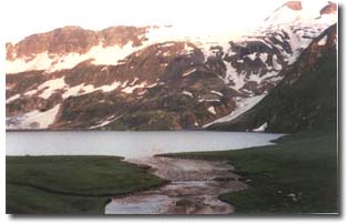
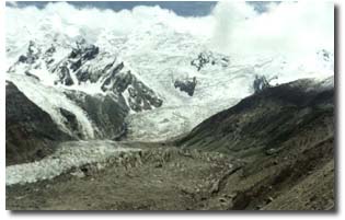
Although Saif-ul-Muluk Lake is the biggest tourist attraction in Kaghan Valley there are a number of other relatively unexplored lakes in the region. Dudipat Lake (Dudipat Sar in local language) is six or seven hours walking distance from Besal. Half of this distance is steady climbing on a clear path then the valley opens out to wide, flat pastureland. The deep blue Dudipat Sar, at 3,800 meters, is surrounded by green hills at about 4,800 meters, with snow patches in the shady hollows. We had brought a fishing rod with us, which were rented from Naran, to try our luck at fishing. Unfortunately the reputation of the lake for its plentiful supply of trout proved wrong and we did not find any fish in the lake.
The sky was very clear and full of stars at night that made camping at the lake a memorable experience. The next morning Dr. Raza decided to go down towards Jal Khad, instead of back to Besal, so that he could see Saral Lake. We therefore parted our ways. I reached Besal in the early afternoon and spent rest of the day cleaning my bike and having a joy ride towards Lulu Sar.
Besal to Babusar top
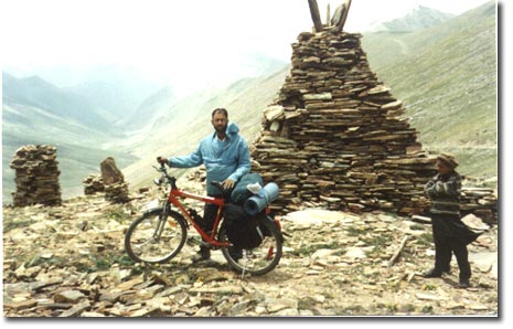
I started early the next morning. The stretch of my journey today was to be the toughest and the longest as I was to cross Babusar pass and reach Chilas before the end of the day. Lulu Sar is 2 km from Besal. The lake is about 3 km long and is the biggest in the valley. The Kunhar River that drains the Kaghan Valley starts from this lake. Biking along the brilliant turquoise lake was a joy. The scenery was captivating and serene. This lake also seemed to be devoid of any fish. I did not see a soul except a few small birds till I reached the village of Gittidas in a little less than three hours. The ordeal was to begin now. I did this track – Naran to Chilas – with a friend on foot about 27 years ago. I still have a vivid memory that the five kilometers before the pass were very tough. It is not only the unremitting slope that makes this part of the track very difficult. The air gets thin at this elevation and road surface is a mix of boulders, gravel and sand. I filled up two bottles of water from a spring before starting the ascent for the pass, as there was to be no water until I reached the top. It did not take me long to realize that trying to ride this track would be a futile effort and I got off my bike. The distance to the top was to be covered on foot, pushing my bike and me. It was an ordeal; I am not sure who was complaining the most: my bike, my knees, or my lungs. It was probably my lungs. I was getting out of breath every ten minutes and resting for twenty. It took me almost five hours to cover the five kilometers to the top. A stronger and a better-trained person would have certainly fared better. I mean no offense to my bike that gives me so much pleasure, but my fitness and training were probably not the only things that proved wanting on this track. A good mountain bike (hand made in USA with titanium frame, etc.) costs more than $ 4,000 and an average mountain bike about $ 1,500. I had paid an equivalent of about $ 200 in Pakistani rupees for my bike. It is Taiwan assembled and has a bright red colored steel frame that is very impressive to behold but is as heavy as a millstone. I wonder how much difference a more expensive bike would have made. I had finished the bottles of water and a packet of ORS when I reached the stony top of the pass.
Finding a teashop at the top was a pleasant surprise. The shop owner also had a couple of tents if someone wished to spend a night there. I did not see any cyclist in the valley or any jeep crossing the pass, but came across several motorcyclists seeking adventure along the route. They seemed to be the only clientele for the shop.
Nanga Parbat is not visible from the top, and one has to walk a couple of kilometers east along the ridge to have a magnificent view of the peak. Views on the two sides of the pass are strikingly different. The ascent to the top is fairly gradual from Kaghan side. Naran is about 2,500 meters, Burawai 2,800 meters, Besal 3,355 meters, and Babusar pass 4,173 meters. I had left the tree line near Burawai about 35 kilometers behind me following a road that is more or less straight. The descent on the other side of the pass was very abrupt – and pine forests were visible from the top beneath my feet when the clouds permitted. Monsoon rains had not started in Kaghan Valley yet, but this side of the pass was already very misty. I stayed for over an hour at the top feeling great that I had accomplished my goal. I have heard that people bike to the top from Chilas side as well – looks very daunting to me.
Babusar top to Chilas
I was to descend an almost vertical wall now. Babusar village at the same elevation as Burawai is only 13 km from the top by a track that zigzags very rapidly. It would have been a great fun for a downhill biking expert. It was real steep. My full force brakes were unable to stop the bike. What if the break cable or the break-lever snaps? I was not even wearing a helmet. I could not balance myself a couple of times and fell down at hairpin bends. It made me cautious and I started getting off the bike for sharp turns or when I felt that it was too steep. It started to rain and hail after about an hour of biking. Fortunately it was not too heavy and did not last long. I had memories of a thick forest from my last visit of this area but there were far fewer trees now. I could see stems of fallen trees everywhere.
As mountain biking is virtually unknown in Pakistan, almost everyone who saw me along the route mistook me as a foreigner. People were usually friendly and I was greeted with shouts of "Hello", "How are you?", "Five rupees", and "What your country name?" whenever I passed by a habitation. Sometimes they would like me to stop and have a chat with them. When I did not feel like stopping I let them believe that I was a foreigner and either kept biking or stopped only briefly.
One nuisance was that children kept pestering me for money, candies, medicine tablets, my cap, whatever – even my bike. I did not want to encourage this behavior therefore never gave them anything. Sometimes I had to talk to them in Urdu so that they know that I was not a foreigner. I learnt that they thought it was all right to ask things from foreigners. I had spent a lot of time in reaching the Babusar top and there was a long way to go to my destination Chilas. I was therefore rushing through the valley along the Thak River as fast as I could. Downhill biking required a lot of concentration too. I was therefore not responding to the shouts of "Hello", "How are you?" I guess children did not like that and at one stage started throwing stones at me from above. Fortunately their stones did not hit me. I had to stop and talk to the elders in the village. The children of course had run away. I was promised that the kids would be reprimanded for their behavior when they were back in the village and will be told not to do such a silly thing again.
The monsoon belt lasted for about 25 or 30 kilometers from the top and the valley then turned absolutely barren. The road also flattened relatively; rather it started to go up and down. During my last visit 27 years ago starting on foot from Besal I reached somewhere around here before sunset and camped for the night. My memory was failing me; I remembered that Chilas was just a couple of kilometers from here. I probably took some transport then from here to Chilas, as otherwise I would have remembered the walk. The road was stretching out and out. I biked for another couple of hours to reach the point where road leaves the Thak River and starts climbing for Chilas town – still about three or four km away. It was not very steep but I was very tired by now and started to walk instead of biking. Mounds of lumber were lying on both sides of the road; so this is where the forests are ending up.
The walk was a memorable experience. The wide barren expanse was in sharp contrast to the narrow wooded valley that I had biked most of the afternoon. Rugged mountains around were awe-inspiring and the setting sun was radiating all sorts of colors. After a while the gray and brown of the mountains began to sink into darkness. A lonely biker too tired to bike with no soul in sight. After walking for an hour or more Chilas town became visible and road started to go down for crossing the Buto Gah River, only to start climbing up again. It was over an hour after the sunset when I was able to find a place in town for spending the night.
Chilas is the capital of Diamer – one of the five administrative districts of the Northern Areas. It used to be an important junction on the ancient trade route. I walked around the town for sometime after having a heavy meal at an Afghani restaurant. It was late and all the bazaars were closed. Chilas is extremely hot during this time of the year but it was pleasant at night. Streams of water from the mountains above gushing through and beneath houses and along the streets were the only sound in an otherwise tranquil night.
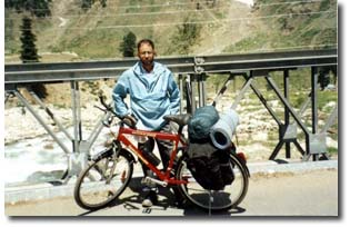
Chilas to Raikot Bridge
I should have started earlier but it was difficult to get up early after a long day. I left Chilas at about 8:00 a.m. for the Karakoram Highway, which is about 3 km down from the town. Biking along the KKH was a joy. There was very little traffic on the road. Biking uphill on a smooth road was less of an effort and you go flying downhill. I was rather careful though and never let my bike go beyond 60 or 70 km. Weather was the only problem as it was getting extremely hot as the day was progressing.
After biking for three or four hours I saw a cyclist resting in the shade of a bridge. He was the first cyclist I had come across. I stopped my bike and climbed down to say hello to him. He was Dietmar Dzieyk – a German living in Austria. He had come to Islamabad by plane and had been biking in the Northern Areas for the last ten days. It was extremely hot (about 45 degrees Centigrade) and Dietmar had chosen a nice cool spot at the bank of a stream (Patro River, probably) to rest. We spent about an hour together during which we had tea, exchanged addresses, and Dietmar wrote me a message for e-mailing his son. As luck would have it, after we had said goodbye to each other and I was about to pickup my bike for my journey onwards a blizzard started that prevented me leaving.
I had moved my luggage down but had left my bike above on the road as I felt that it was too heavy to carry down and then back up. I had locked my bike and had put it flat on the ground so that the handlebar was visible from where we were sitting and was keeping an eye on it. Suddenly I noticed that the handlebar was not visible anymore! I rushed up ignoring the blizzard and saw a man putting my bike in a truck standing on the road. When he heard my shouts and saw me coming he put the bike back on the ground and drove away. Thank goodness a disaster was averted. The numberplate of the truck was covered with dirt. The wind was very strong and it was not possible to move the bike down now. I therefore had no choice but to stay on the road for keeping a watch on my bike, facing the wind and the rain. Getting soaked in the rain after a hot day was very refreshing actually.
Strong wind and rain lasted for quite some time and prevented me from leaving. Dietmar decided to camp at the bank of the river for the night and invited me to stay with him. I did not have any other choice and so readily accepted the offer. Next morning we biked together to Raikot Bridge. Dietmar wanted to see Nanga Parbat, and I was finding it hard to bike along KKH because of the very hot weather. I spent the next three days with Dietmar during which we camped two nights at the famous tourist spot Fairy Meadows and visited the base camp of Nanga Parbat.
Fairy Meadows
Raikot Sarai (Raikot Inn) at Fairy Meadows was humming with German speaking people, mostly Austrians. Since there were so many Austrians around, Dietmar sometimes illumined me about the relationship between Austrian and German peoples. He told me that there was no love lost between the two and although both spoke the same language, the accents were different. Since Dietmar (a German living in Austria) has Austrian numberplate on his car, whenever he travels abroad to countries like Greece, Austrian tourists there give him an enthusiastic welcome but when they hear his accent the enthusiasm dissipates immediately. "When an Austrian invites you to his home he is surprised when you visit him”, and “when an Austrian invites you to his home he opens all the doors except one – his heart", he said. There were two cyclists from the German speaking north of Italy. One of them, Hans, was a Computer Science student at Vienna. He told me that because of his ethnicity he is not charged any dues at Austrian universities while in his own country Italy he has to pay full fees. Hans also told me that world's most renowned Italian mountaineer Reinhold Messer is actually a German and he was a Math teacher before he learnt that more money can be made by going up and down the mountains. I wished I had known that too.
It was amusing for me to note these differences. I wished the countries of the Indian Subcontinent were also living in peace with each other despite their political, cultural and religious differences; then they would not have to spend all their resources on a military buildup and the poor in these countries would not be so inhumanly poor.
When we go to Western countries every thing looks well organized and orderly. Likewise when westerners come to our countries they find every thing grubby, chaotic and strikingly different from what they are used to. Stefan (Italian/German cyclist) once expressed his amazement about the difference between roads in the two parts of the world. I commented that differences were many. Dietmar once asked me why people here were so dirty; they didn’t seem to wash their clothes. I did not have an answer. We are so used to it that we hardy ever notice it and when we notice it poverty seems to be the obvious reason. But poverty certainly is not the only reason; we are never educated about the importance of cleanliness and hygiene. Even people who are not poor by any standards are sometimes indifferent about cleanliness. I think the difference is also noticeable among the affluent countries. Perhaps some cultures give more value to cleanliness and aesthetics than others. I believe that Japanese have better aesthetic sense than any other people in the world. I have never been to Japan though so I should ask someone who has seen the world.
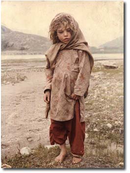
Dietmar, who is a Buddhist convert, sometimes talked about the depression he felt seeing poverty of people in the mountains, particularly children. Once he started to teach a very innocent looking child how to wash his face. I doubt if the child enjoyed being washed with ice-cold water but he was certainly very pleased when Dietmar gave him some candies and biscuits. Dietmar then took a picture of the child smiling; he should have taken one before the ritual as well.
Dietmar and I came back to Raikot Bridge on July 15. The sun was really “raining fire” on KKH. I guess it is part of the adventure for people who come from countries with cooler climates, but I was finding the heat unbearable. Biking in this weather did not seem like fun to me so I bid farewell to Dietmar and put my bike on a NATCO (Northern Area Transport Corporation) bus bound for Rawalpindi and came back home. Weather was not the main reason for turning back – if Austrians and Germans can stand the sun why can’t a Lahori. I had used only low gears in the Kaghan Valley but on the KKH I needed the full range of gears, and my bike was having problems shifting gears. My program was for a couple of weeks anyway. I had already spent eleven days and had started missing food at home! KKH – may be some other time. Who Knows I may be able to buy a better bike one-day?Epilogue
Mountain biking is an Olympic sport and is becoming increasingly popular in the world. It needs to be promoted in Pakistan in an organized manner. A biking rally can be instituted from Gilgit to Chitral for introducing mountain biking in the country. In time this rally will acquire international status and will help promote tourism in this country. People in the northern areas of Pakistan are very hardy and strong. I would love to see someone from Gilgit or Chitral win Olympic gold medal for the country by the year 2008. What a way it could be to put Diamer on the world map! I am sure by proper planning Pakistan can acquire the same status in mountain biking as it has in squash at present.
Shoaib ud Din
shoaibdin@hotmail.com
| Home | Cycling the Babusar Pass |
| Allama Iqbal Society for Promotion of Education |
| A proposal for Examination Practice and Evaluation Reform |
| Operations Research and its Prospects in Pakistan |
| From Abbotabad to Thandyani and Beyond …. |